Log in
All resources
Create a design
269 Free Artworks of Languages Of Africa
bibliothèque nationale de france
eran laor cartographic collection
1667 sanson map of africa
herman padtbrugge
french-language maps
maps from gallica
maps by pieter mortier
1570s maps of egypt
maps of cairo by braun & hogenberg
cairo in the 16th century
1667 sanson map of africa
1702 maps of africa
maps by hendrik hondius the younger
1632 maps of africa
maps by jean-baptiste bourguignon d'anville
1727 maps of africa
maps by louis brion de la tour
1786 maps of africa
maps by jean-baptiste bourguignon d'anville
maps by isaak tirion
maps by willem and johannes blaeu
1663 maps of africa
bibliothèque nationale de france
1667 sanson map of africa
bibliothèque nationale de france
1667 sanson map of africa
bibliothèque nationale de france
1667 sanson map of africa
bibliothèque nationale de france
1667 sanson map of africa
maps by willem and johannes blaeu
1640 maps of africa
bibliothèque nationale de france
1667 sanson map of africa
arnold van langren map of southwest africa
1596 maps of africa
bibliothèque nationale de france
1667 sanson map of africa
19th-century maps of gabon
1877 maps of africa
17th-century maps of africa
maps from gallica
eran laor cartographic collection
guillaume sanson
arnold van langren map of east africa
1600 maps of africa
context files from gallica
1667 sanson map of africa
maps by willem and johannes blaeu
1640 maps of africa
eran laor cartographic collection
pierre mortier
arnold van langren map of southwest africa
bibliothèque nationale de france
arnold van langren map of east africa
bibliothèque nationale de france
french-language maps of south africa
1876 maps of africa
18th-century maps of north africa
maps by tomas lopez
arnold van langren map of southwest africa
renaissance
maps of barbary coast by mercator-hondius
bibliothèque nationale de france
1572 maps of africa
1570s maps of egypt
1880s maps of tunisia
maps from gallica
maps of rivers of equatorial guinea
komo (river)
maps by pieter mortier
maps from gallica
1836 maps of africa
ambroise tardieu
arnold van langren map of southwest africa
renaissance
cartouches by willem and johannes blaeu
bibliothèque nationale de france
hendrik van langren map of south asia
1595 maps of asia
eran laor cartographic collection
william henry toms
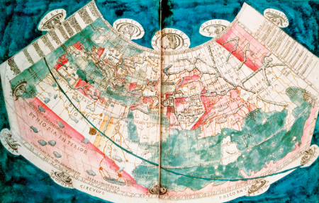
tresor des cartes geographiques (1659)
1659 maps of africa
nouvelle géographie universelle
1887 maps of africa
maps by pieter mortier
maps from gallica
carte particulière des costes de l'afrique qui comprend le royaume de gualata ... - btv1b8595466g
maps by pieter mortier
carte particulière des costes de l'afrique qui comprend le royaume de gualata ... - btv1b8595466g
maps by pieter mortier
atlas sive cosmographicae (gerardus mercator, 1607)
maps of africa by mercator-hondius
maps by pieter mortier
maps from gallica
eran laor cartographic collection
william henry toms
1565 maps of asia
niccolo nelli
1572 maps of africa
1570s maps of egypt
17th-century maps of west africa
1650 maps of africa
maps of barbary coast by mercator-hondius
bibliothèque nationale de france
hendrik van langren map of south asia
1600 maps of asia
carte de barbarie, nigritie, guinée par guillaume delisle (1707)
bibliothèque nationale de france
1574 maps of africa
1570s maps of egypt
carte de barbarie, nigritie, guinée par guillaume delisle (1707)
bibliothèque nationale de france
eran laor cartographic collection
alexis-hubert jaillot
eran laor cartographic collection
william henry toms
1570s maps of africa
1570s maps of egypt
19th-century maps of africa
raymond bonheur
bibliothèque nationale de france
niccolo nelli
nelle presenti tre tavole sono le marine secondo le carte da navicar, et fra terra secondo i migliori scrittoriantichi et moderni. con fiumi, moti, laghi, mari, citta, provincie et capi principali... - btv1b55004675g
bibliothèque nationale de france
nelle presenti tre tavole sono le marine secondo le carte da navicar, et fra terra secondo i migliori scrittoriantichi et moderni. con fiumi, moti, laghi, mari, citta, provincie et capi principali... - btv1b55004675g
bibliothèque nationale de france
eran laor cartographic collection
william henry toms
atlas sive cosmographicae (gerardus mercator, 1630)
maps of africa by rumold mercator
atlas sive cosmographicae (gerardus mercator, 1630)
maps of africa by mercator-hondius
maps by tomas lopez
1785 maps of africa
nelle presenti tre tavole sono descritte le marine secondo le carte da navicar et fra terra secondo i migliori scrittori antichi et moderni, con fumi, monti, laghi, mari, citta, provincie et capi principale... - btv1b8468487h
bibliothèque nationale de france
1727 maps of africa
1720s maps of egypt
1727 maps of africa
1720s maps of egypt
bibliothèque nationale de france
niccolo nelli
atlas sive cosmographicae (gerardus mercator, 4th edition 1613)
maps of africa by mercator-hondius
nelle presenti tre tavole sono descritte le marine secondo le carte da navicar et fra terra secondo i migliori scrittori antichi et moderni, con fumi, monti, laghi, mari, citta, provincie et capi principale... - btv1b8468487h
bibliothèque nationale de france
nelle presenti tre tavole sono descritte le marine secondo le carte da navicar et fra terra secondo i migliori scrittori antichi et moderni, con fumi, monti, laghi, mari, citta, provincie et capi principale... - btv1b8468487h
bibliothèque nationale de france
hendrik van langren map of south asia
1595 maps of asia
1630s maps of ethiopia
1635 maps of africa
1570s maps of africa
1570s maps of egypt
ptolemy's second projection
emery walker
1720s maps showing history
1727 maps of africa
jean-fréderic phélypeaux
guillaume dheulland
eran laor cartographic collection
emanuel bowen
16th-century maps of the western mediterranean
lucas janszoon waghenaer
reverse sides from gallica
herman padtbrugge
west-indische paskaert (doncker, 1660s)
herman padtbrugge
reverse sides from gallica
herman padtbrugge
reverse sides from gallica
herman padtbrugge
west-indische paskaert (doncker, 1660s)
herman padtbrugge
west-indische paskaert (doncker, 1660s)
herman padtbrugge
west-indische paskaert (doncker, 1660s)
herman padtbrugge
reverse sides from gallica
herman padtbrugge
eran laor cartographic collection
jacques chiquet
carte de barbarie, nigritie, guinée par guillaume delisle (1707)
bibliothèque nationale de france
bibliothèque nationale de france
niccolo nelli
bibliothèque nationale de france
guillaume sanson
context files from gallica
lucas janszoon waghenaer
context files from gallica
lucas janszoon waghenaer
le sénégal. la france dans l'afrique occidentale (1889)
orientalist painting
1470s maps of the world
latin-language maps
atlas minor gerardi mercatoris (1614, maps)
maps of africa by mercator-hondius
17th-century maps of the indian ocean
maps by willem and johannes blaeu
18th-century maps of north africa
maps by tomas lopez
1770s maps of algeria
maps by tomas lopez
maps of tangier by braun & hogenberg
maps of safi by braun & hogenberg
1572 maps of africa
1570s maps of egypt
101 - 200 of 269
Next page
/ 3


![Aethiopia inferior, vel exterior, partes magis septentrionales, quae hic desiderantur, vide in tabula Aethiopiae superioris / [Joan Blaeu], 1663](https://cdn.creazilla.com/illustrations/10000599277/aethiopia-inferior-vel-exterior-partes-magis-septentrionales-quae-hic-desiderantur-vide-in-tabula-aethiopiae-superioris-joan-blaeu-1663-md.jpg)


![Treasure of geographical maps of the main states of the universe [...], 1659](https://cdn.creazilla.com/illustrations/10001227179/treasure-of-geographical-maps-of-the-main-states-of-the-universe-1659-md.jpg)